Bali Facts & Figures
Location: Nusa Tenggara Province of Indonesia, between Java and Lombok
Area: The island of Bali has an area of 5,632.86 square kilometers.
Name: Bali
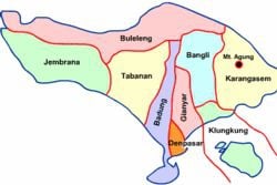
Districts: The Province of Bali is divided into 9 districts (8 Regencies and 1 Municipality - Denpasar)
The 9 districts are further sub-divided into 51 sub-districts, 565 villages, and 79 local political districts.
Bali Islands: There are several smaller islands off the coast of Bali, including Nusa Penida, Nusa Ceningan, Nusa Lembongan, and Serangan Island in the south-east, and Menjangan in the north-west, off the Bali Barat National Park coastline.
Capital City: Denpasar
Population: 3,891,428 (2010) Mostly Balinese
Ethnicity: Balinese (89%), Javanese (7%), Baliaga (1%), Madurese (1%)
Language: Bahasa Indonesian (official), Balinese, English
Largest Cities: (by population) Denpasar, Singaraja, Tabanan, Negara, Kuta, Ubud, Klungkung
National Day: August 17th - Indonesian Independence Day
Religions: Hindu (92.29%), Muslim (5.69%), Christian (1.38%), Buddhist (0.64%)
Lakes in Bali:
Lake Beratan (375,6 Ha),
Lake Buyan (336 Ha),
Lake Tamblingan (11 Ha) and
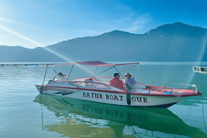
Lake Batur (1.607,5 Ha).
Volcanoes in Bali:
Gunung Agung (3148m)
Gunung Batukaru (2276m)
Gunun Abang (2151m)
Gunung Catur (2096m)
Gunung Sengayang (2087m)
Gunung Pohen (2063m)
Gunung Lesong (1865m)
Gunung Adeng (1826m)
Gunung Batur (1717M)
In West Bali National Park are the small peaks, G.Merbuk, G.Mus, G.Mesehe, G.Patas
Major Festivals in Bali:
Galungan, Nyepi, Saraswati and District Arts Festivals are some of the major festivals. Christmas is also celebrated, as in all of Indonesia. Many Bali hotels and restaurants serve Christmas lunch and dinner.
Best time to visit Bali:
May to September, the dry season - or the rest of the year, if you do not mind some rain.
Places to Visit:
See our Things to do section.
Harbours and ports:
Benoa Harbour (Tanjung Benoa)
Raya Pelabuhan Benoa St, Pedungan Village, South Denpasar, Bali
Main harbour for commercial vessels, boats to Nusa Penida, Nusa Lembongan, Nusa Ceningan, Lombok and Gili Islands. Cruise liners dock here.
Padangbai for ferries and fastboats to Lombok and Gili Islands
Gilimanuk for ferries to Java from north-west coast
Singaraja on the north coast, now replaced by
Celukan Bawang, approximately 70 km from Singaraja.
Main ferry line - between all Indonesian islands:
PELNI office at Benoa Harbour
Phone: (62-361) 721 377.
PELNI office in Denpasar
Jl. Diponegoro 165
Phone: (62-361) 234 680.
Geography:
Bali lies 3.2 km (2 mi) east of Java, and is approximately 8 degrees south of the equator. Bali and Java are separated by the Bali Strait. To the north of the island is the Bali Sea and to the south is the Indian Ocean. Bali is separated from Lombok, to its east, by the Selat Lombok.
Latitude & Longitude: Denpasar (capital city)(08° 39' S, 115° 13' E)
Horizontal Width: 54.08 miles (87.03 km) from Gilimanuk east to Catur
Vertical Length: 62.15 miles (100.02 km) from Yeh Sanih south to Sanur
Geographic Centre: About 16.28 miles (26.2 km) southwest of Catur
Highest Point: Mount Agung 10,328 ft. (3,148 m)
Lowest Point: Bali Sea 0
Weather:
Bali experiences pleasant, low-humidity conditions with average daily temperatures between 70 and 93 degrees (21 - 33°C) year-round. The island's rainy season is December through March, with most of the showers occurring in the evening.
The island's central mountains include several peaks over 3,000 meters in elevation. The highest is Mount Agung, standing at 10,328 ft. (3,148 m). An active volcano known as the "Mother Mountain", it last erupted in 1963, with lava flows devastating numerous villages and killing 1,500 people.
Bali's volcanic nature has contributed to its exceptional fertility, and its tall mountain ranges provide the abundant rainfall that supports the highly productive agricultural sector. South of the mountains is a broad, steadily descending plain where most of Bali's large rice crop is grown.
On the northern side of the mountains, the terrain slopes more steeply to the sea. This is the main coffee-producing area of the island, along with rice, vegetables and cattle.
Dozens of very small rivers drain the island. The longest river, the Ayung, flows approximately 75 km.
The island is surrounded by coral reefs. Beaches in the south tend to have white sand, while those in the north and west have black sand.
____________________________________________________________________________________________________
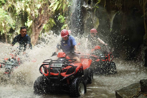
Top Experiences and Tours in Bali
If youʻre booking your trip to Bali last minute, we have you covered. Below are some of the top tours and experiences!